Govt. Regd. No.: 129729 / 071 / 072 | Tourism. Regd. No.: 1861/ 071
WHATSAPP/VIBER+977 9803122552 (DHAN)
Get Expert Advise[email protected]
About Nepal
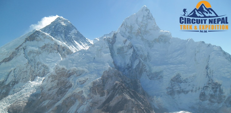
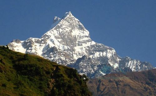
Mount Everest (8848 m) highest peak of the world.
Nepal is a combination of ancient history, vibrant cultures and scenic splendor. Located between China and India, Nepals main geographical features include snow-capped peaks, lower mountains, hills and lush Terai plains of tropical jungles.
Nearly one- third of the total length of the Himalayas and 8 of the worlds 14 highest peaks are in Nepal. The landlocked country covers an area 147,181 sq. kilometers ranging from 70 meter to the highest point at 8848 meters above sea level. Nepals popularity as a tourist destination has increased greatly over the years.
While trekking and mountaineering have long been popular, an entire range of other activities are carried out. With the variety of adventure options, the country is a favorite among adventure lovers.
Continent: Asia
Location: Situated between India and Tibet, an autonomous region of the peoples republic of China.
1) Latitude: 26* 22 and 30* 27 North
2. Longitude: 80* 4 and 88* 12 East
Area: 147,181 sq.kms
Capital: Kathmandu
Time Zone: 5 hours 45minutes \ahead of GMT.
People: Nepal has more than 100 ethnic groups and over 125 spoken languages
Population: About 26 million
Population growth rate: 2.25 per annum
Currency: Nepali Rupees (approximately US$ 1 equal to 70)
Language: Nepali is the national language however travels trade people understand and speak English as Well.
Political System: Multiparty Democracy System
Topography: From the worlds deepest gorge “kali- Gandaki to highest point on earth” the Everest.
Vegetation: Nepal possesses wide range of vegetation due to its unique topographical variation.
Weather: Climate ranges from tropical in the low lands to arctic in higher altitudes.
Season: Nepal has four major season:-
1) winter (December – February)
2)spring (March - May)
3)summer (June – August)
4)Autumn ( September – November)
Nepal can visited whole year around.
What to wear: Light weight cloth is recommended for May through October, warm garment are required In October – March, An umbrella or raincoat is must for the rainy season.
Monsoon: Mostly rains day and night, making following days crispy clean and fresh. Most of the Northern belt of the trans- Himalayan zone is rain shadowed and ideal for trekking especially such as Upper Mustang, Dolpo, Manaslu, Around Annapurna etc.
Political System: Nepal was declared a Federal Democratic Republic state on May 28, 2008, during the first meeting of the Constituent Assembly. It was previously a multiparty democracy since 1990
National flower: Red Rhododendron (Laligurash)
National Animal: Cow
National Bird: Dafe (Impeyan Pheasant)
World Heritage Site (Cultural):
1, Kathmandu Durbar Square
2, Pashupatinath
3, Boudhanath
4, Swayambhunath (Monkey Temple)
5, Chagunarayan
6, Patan Durbar Square
7, Bhaktapur Durbar Square
8, Lumbini
World Heritage site (Natural):
1) Sagarmatha National Park (Everest Region)
2) Royal Chitwan National Park
History and Geography:
History: According to myth, once upon a time the Kathmandu Valley was a great lake in the middle of which a brilliant flame burned from a lotus flower. Manjushri, a Buddhist from China, smote the lake with a magical sword and the water was drained from it. It is said that Swayambhu appeared in the flame when the Valley was formed. But according to the Hindu religion, Krishna created the valley, hurling a thunderbolt at the lake to create the Chorbar gorge.
The rivers of the valley do indeed flow southward through the narrow gorge and scientists agree that the valley was once submerged. The recorded history of Nepal began with the reign of the Kiratis from the eastern part of the country. Yalamar, the first of their kings, is mentioned in the Hindu epic, The Mahabharata. During the Kirati period, Buddhism was introduced to the country.
Krakuchhanda Buddha, Kanak Muni Buddha and Kashyapa Buddha visited the Kathmandu valley to worship Swayambhunath. After Kiratis, the Lichhavis ruled from the 4th to the 7th century. The temple of Changunarayan was built in Licchavi period, and can still be seen today.
The Malla period was a golden era in Kathmandu valley, when great art, statues and temples were created. During the 147th century, Malla ruled for a total of 568 years. The country was divided into many small principalities and kingdoms, and the Kathmandu valley was divided into three states; Kantipur, Lalitpur & Bhaktapur.
In the tiny Kingdom of Gorkha, halfway between Kathmandu and Pokhara, the Shah dynasty gradually extended their power. In 1768, King Prithivi Narayan Shah defeated the Malla kings and Nepal has been ruled by Shah kings ever since. Our present king, His Majesty King Gyanendra Bir Bikram Shah Dev is the eleventh king in the shah dynasty.
Geography: Nepal is a mountainous kingdom, located in Southern of Asia. It is a land locked, situated between China to the North and India to the South East and West. The area of Nepal is 1, 47,181 sq. km - which covers 0.3 percent of Asia and 0.03 percent area of the world. It lies between latitudes of 26? 22? and 30? 27? North and longitudes of 80? 4? and 88? 12? East. The country is only about 880 km. from East to West and its breadth varies from 145 to 241 km.
The topography changes dramatically within a short lateral distance. There is a narrow strip of low lands in the south. Further north lie the Himalayan foot hills and ranges which run roughly east-west across the country and include eight of the highest peaks in the world - each over 8000m. Geographically, Nepal is divided into three main regions: The Himalayan Region, the Hilly Region and the Terai plain region.
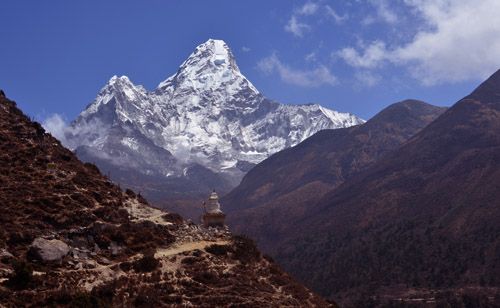
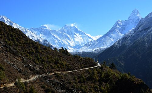
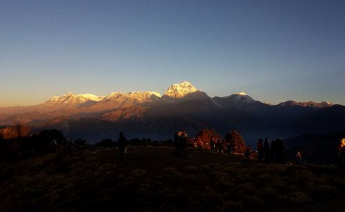
The mountainous region covers 15 percent of the total area of the northern side of the country, lying horizontally at altitudes of 4700m and higher. In this region snow falls every season and mountains such as Everest (8848m) have attracted adventurers for many decades. Another attraction of this region are the kundas (big lakes) and several national parks and wild life reserves, including Sagarmatha National Park, which is a world heritage site. In this region, you can see Sherpa settlements and perhaps sightings of snow bears and Yeti footprints.
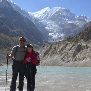
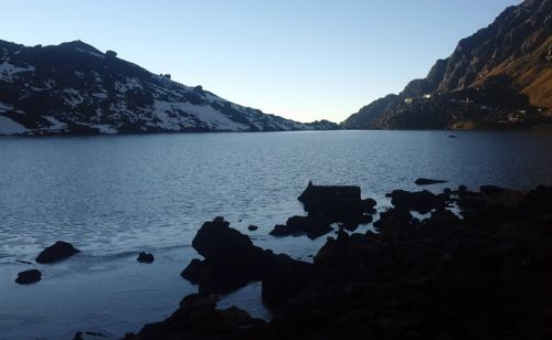
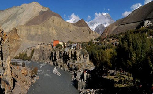
The hilly region forms 68 percent of the country, and is formed by the Mahabharat range that soars to touch mountain region, with altitudes of 600 to 4,700 m. In winter, snow may fall in the higher areas. This region is formed by beautiful valleys like Kathmandu and Pokhara and famous for its lakes, in Pokhara Phewa, Begnas, Rupa etc. and the Tilicho lake in Manang District, which are wonderful for swimming and boating. There are three major rivers, the Koshi, Gandaki and Karnali.
Additional attractions in this region are Nagarkot and Dhulikhel, where the heart-stopping beauty of a sunrise can be viewed as never before. Most of the snow covered mountain ranges can be enjoyed from hill tops of Nagarkot, Phulchoki and Pokhara.
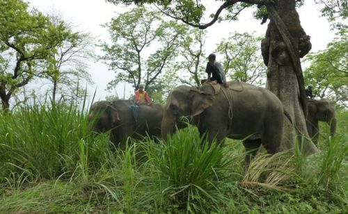
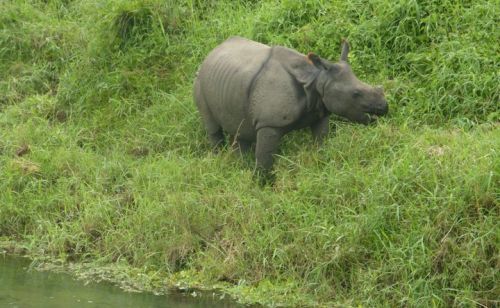
The Terai region covers 17 percent of the total, with an altitude of 70m to 600m above sea level. This is the region of religious icons, national parks, and wild life reserves. The most famous holy places are Janakpur, Lumbini and Barahachhetra. Lumbini was the birthplace of Lord Buddha, the champion of world peace. There are four national parks and wild life reserves in this region. Among them the Royal Chitwan National park, with its rhinoceros. This region is also noted as the place where most trekkers take the first steps of their adventure.
People, Religion & Culture
People: Nepals population is made up of more than two crore of tribes, living in different regions, wearing different costumes and speaking different languages and dialects. The Sherpas live mainly in the mountains of eastern and central Nepal, in particular in the Solu Khumbu region. The Sherpas are probably the best known Nepalese ethnic group. Originally from Tibet, they first settled about 500 years ago. The Sherpas - also known as "the tigers of the snow" live in the Himalaya region up to an average altitude of 4,570m.
Bahuns and Chhetris are the two highest castes; and live throughout the Kingdom. The progeny of Bahun men and hill women were considered Chhetri and a number of high status families from other hill groups have also adopted Chhetri status, though some have Mongoloid ancestry. All Bahuns and Chhetris are Hindu. The Newars constitute and important ethnic group in the capital. The Newaris of the Kathmandu valley are a good example of the result of our Himalayan melting pot. The Gurung and Magars live mainly in the west and on the southern slopes of the Annapurna, Himalchuli and Ganesh Himal mountains. The Magars and Gurungs often find as soldiers in the famous Gurkha regiments.
The Rais, Limbus, and Sunuwars inhabit the slops and valleys of the eastern mid hills and many have migrated to the eastern Terai. Tamangs are one of the largest Tibet - Burman ethnic groups in Nepal. Around half the Himalayan zone of Nepal is inhabited by Tamangs.
Many Tamangs have been influenced in their dress by both western and Newari styles. Traditionally, women wear a colorful wraparound skirt, a blouse, jacket and scarf. On important occasions they wear chunky gold or brass ear and nose rings set with semiprecious stones. Men wear loincloths or the traditional Newari pants, short-sleeved jackets and topis. Both men and women wear several meters of cloth wrapped around the waist.
The Thakalis live mainly in the Kali Gandaki valley in central Nepal, and are a Tibeto Burman people who have become the entrepreneurs of Nepal. Originally Buddhist, many pragmatic Thakalis have now adopted Hinduism. The actual number of Thakalis is very small.
Tharus, Yadavs, Satar, Rajvanshis, and Dhimals are spread generally in the Terai region. Tharus are one of the largest ethic group in Nepal.
Religion: Hinduism and Buddhism share between them some 86.5 and 7.8 percent of the total population respectively. Their sense of fellow- feeling and bonhomie is evident in their worship of common deities and the joint celebration of many festivals. Buddhism was introduced in Kathmandu valley by Emperor Ashoka of India around 250 BC. Later, around 8th century AD, the ancestors of the Sherpas emigrated from Tibet bringing with them a form of Buddhism known as Ningmapa.
Gurungs, Tamangs, Serpas and Newars in the Kathmandu valley also follow Mahayaa Buddhism and the famous temple of Swayambhu in Kathmandu and the "Golden Temple" or the Hiranya Varna Mahabihar in Patan are visited mainly by Buddhist Newars.
A few people have adopted a complex blend of both Hinduism and Buddhism known as Bajrayana, which is mainly practiced in the Kathmandu valley. Apart from the Hindus and Buddhists, Muslims (3.5%) form the third largest religious group. There has also been an increase in the number of Christians in Nepal in recent years, now around 40,000 - about 1% of the population and 1.2 percent of other religions.
Culture: Nepal is host to two main religions - Hinduism and Buddhism, two races, Caucasoid and Mongoloid and two civilizations, Indic and Sinic. Each ethnic group has its distinct identity. Although legislation banned it in the sixties, Polygamy is stilled practiced in some areas.
On entering a Nepalese home it is polite to remove your shoes. Some westernized Nepalese might not do it, but it is much appreciated. Many Hindu temples do not admit westerners to enter. Always walk clockwise around Buddhist Stupas, Chhortens or Mani walls. Shoes and any other leather items such as belts and bags must be removed before entering a Buddhist or Hindu temple Public displays of affection are not considered polite. Nor should you think of swimming naked in our rivers and lakes. In the northern hill area, polyandry, the custom of a wife having more than one husband, was also practised till recently. For a widow to re-marry was not socially acceptable in some groups. An ethnic group such as the Brahmins were prohibited from drinking alcohol and sometimes practice vegetarianism. Brahmins met their spouse for the first time on the day of the wedding.
World Heritage Sites
The small mountain kingdom of Nepal is blessed with such astonishing and unique sites that within the area of 1,47,181 sq km Nepal holds a considerably high number of places recognized by UNESCO (United Nations Educational Scientific Cultural Organisation) as World Heritage Sites. There are altogether ten World Heritage Sites in Nepal, seven of which are in Kathmandu itself. The list includes both natural as well as cultural sites.
A) Cultural Sites: The cultural heritage of the Kathmandu Valley is illustrated by seven groups of monuments and buildings which display the full range of historic and artistic achievements for which the Kathmandu Valley is world famous. The seven sites include the Durbar Squares of Hanuman Dhoka (Kathmandu), Patan and Bhaktapur, the Buddhist stupas of Swayambhu and Bauddhanath, and the Hindu temples of Pashupati and Changu Narayan. Click on the following links to get detailed information about the individual sites.
- Kathmandu Durbar Square
- Patan Durbar Square
- Bhaktapur Durbar Square
- Changu Narayan Temple
- Swayambhunath Stupa
- Pashupatinath Temple
- Lumbini
- Bouddhanath Stupa
B) Natural Sites: Nepals national parks included in the World Heritage Sites List are exceptional areas with dramatic mountains, glaciers, deep valleys and undisturbed vestiges of the Terai region. Several rare species, such as the Snow Leopard, Lesser Panda, Single-horned Asiatic rhinoceros and the Bengal tiger are found in these park.
1) Chitwan National Park
2) Sagarmatha National Park
UNESCO World Heritage Sites
The World Heritage List includes 830 properties forming part of the cultural and natural heritage which the World Heritage Committee considers as having outstanding universal value.These include 644 cultural, 162 natural and 24 mixed properties. Out of these 10 sites are from Nepal itself. Seven out of these are cultural and two natural.
Some Nepal Sites/Properties submitted on the Tentative List of UNESCO
The early medieval architectural complex of Panauti (1996)
Tilaurakot, the archaeological remains of ancient Shakya Kingdom (1996). Cave architecture of Muktinath Valley of Mustang (1996)
The medieval palace complex of Gorkha (1996)
Ramagrama, the relic stupa of Lord Buddha (1996)
Khokana, the vernacular village and its mustard-oil seed industrial heritage (1996).
Company Info
Client Reviews
Notre trek, autour des Annapurna, avec Dhan Bahadur et son équipe de porteurs a été très réussi. Nous avons passé un excellent séjour dans des paysages fabuleux, et en très bonne compagnie! Et des soirées inoubliables avec toute l'équipe! Cela fait deux fois que…... continue
Martine Guérin, France
Trip Advisor
Get Expert Support
OUR SPECIAL OFFER
Everest Panorama Trek- 11 Days
11 Days
Chitwan Jungle Safari
3 Days
Bardia Jungle Safari
3 Days
Mardi Himal Trek- 10 Days
10 Days
Lower Dolpo Trek
24 Days